

The Rockland Breakwater is listed on the National Register of Historic Places. The application for that listing is here and has lots of good information.
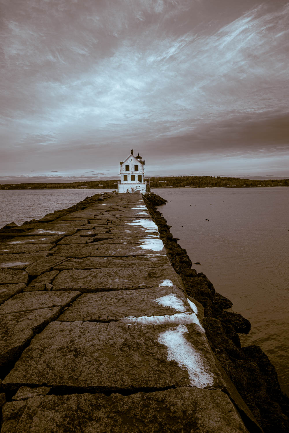
The Rockland Breakwater is a granite structure constructed at the mouth of Rockland Harbor in order to enhance the safety and navigability of the harbor. The Breakwater is located at the eastern edge of a small cove on the southernmost tip of Jameson Point, which projects from northwest to southeast into the harbor, approximately 1.25 miles east of the Rockland Inner Harbor. The Breakwater is also oriented northwest to southeast. It extends 4,346 feet into the harbor, and is 43 feet wide at the top. A brick and granite light station is located atop the southern tip of this jetty (Rockland Breakwater Lighthouse, NR 81000067). The depth of the breakwater at this point is 65 feet, and the width of the rubble base is 175 feet. An estimated 697,627 tons of granite was used in the construction.
Built between 1881 and 1900, the majority of the breakwater is located beneath sea level. Historic construction diagrams indicate that the wide rubble base is constructed at a 45 degree angle from the base of the structure to a point 14 feet above mean high water on the west side. The 30 degree slope on the eastern side was more gradual, but larger in mass and designed to withstand constant battering from the waves on the seaward side. The top of the breakwater is capped with a course of flat, rectangular granite blocks, laid three across. Historically this cap was smooth enough to allow automobiles to travel to the lighthouse at the end of the breakwater, however this is no longer possible due to the effects of slight shifts and weathering. Below the top course on the western side are two courses of similar cut-granite blocks, stepped out to form an ever-widening platform, which below the water line becomes the tapered rubble base. The eastern (seaward) side of the breakwater below the cap consists of less carefully laid, irregular granite blocks that taper from the flat cap to the submerged base. The first 204.5 feet of the structure serves as a connector from the land to the start of the breakwater proper and the widely scattered granite rocks forming the base and sides in this section serve more to protect the land than to break the waves. The entire structure is dry-laid, with small rocks used for fill as needed. The exposed stones show evidence of three splitting technologies: pin and feather, steam-powered rock hammer and pneumatic drill.
STATEMENT OF SIGNIFICANCE
The Rockland Breakwater is a 4,346 long granite structure that stretches across the mouth of the broad Rockland Harbor south from Jameson Point. At its southern terminus the breakwater supports the Rockland Breakwater Lighthouse (NR 81000067), beyond which is approximately 1 mile of open water before reaching the south side of the harbor at Battery Point. The structure was constructed by the United States Army Corps of Engineers between 1881 and 1900 to protect the maritime industries of Rockland and provide a harbor of refuge for coastal traveling vessels. It is eligible under Criterion A for its role in fostering the economic growth of Rockland’s maritime, lime and granite industries, and under Criterion C as an example of 19th century breakwater designed by the United States Army Corps of Engineers using local materials.
The significance of the Breakwater to Rockland’s economy was great, as the majority of industries revolved around the harbor. The lime extraction, cement production and granite quarrying industries that were based in Rockland starting in the early 19th century relied heavily on shipping for the distribution of their products. In turn the residents and commercial establishments relied on regular shipments of wood, raw materials, and supplies that vessels brought with them into port. As with many other ports, ship building and fishing contributed heavily to the local economy; but the strength of these business relied on a safe and navigable harbor. It was early regarded as one of the best harbors along the coast, east of Portland, and was frequently sought out as a port of refuge during storms (Bacon, p. 5). Yet, the broad mouth of the harbor allowed frequent storms with northeast winds to batter the vessels, and overall it was considered to be unsafe under these conditions. As early as 1832 a small sea wall was built to protect the wharves and vessels during storms. This project led the Army corps of Engineers to survey the harbor two years later and recommend the construction of an extensive breakwater; however no construction ever resulted from this study. The subject again became a topic of discussion in the 1850s after two storms battered the extensively developed shoreline and destroyed several vessels. Although the need to improve the harbor received a nod of understanding from the United States Senate, it was not until 1880 that the 46th Congress appropriated $20,000 for the building of a “rubble-stone breakwater for the protection of the harbor against the easterly storms to which it is much exposed”. (As quoted in ShoreVillage Story, p. 336).
As initially conceived and designed there were to be two separate breakwaters, one stretching south just offshore from Jameson Point, and the second , located at South Ledge was to run 2,640 north towards the point. Construction started on the Jameson Point section first, and in time it was decided to jettison the second breakwater and concentrate on extending and strengthening the first structure. The first of nine contracts was given to the Bodwell Granite Company of Rockland, and construction on the first 1900 feet of breakwater commenced in 1881. The following excepts from Shore Village Story describe the nine stages of building:
This initial section of the breakwater was started 204 feet from the shore and extended 657 feet. Stone (mostly granite) was delivered by sloops and lowered into the water from derricks attached to the ship’s masts. The blocks of granite, some weighing several thousand pounds, were dropped into the water forming a trapezoid of rough irregular stone (rubble stones). The comparatively even surface seen above the water line was added later in a process described as “capping” the work. Colonel George Thorn engineered this first section of the breakwater and reported on the possibilities of the entire project to the Chief of Army
Engineers. Soundings and plans allowed the various engineers who designed the nine sections of the Rockland Breakwater to work with some continuity, and inspectors (hired by theGovernment) insured the quality of the work. (Mr. A.D. Blackington of Rockland was the first inspector).
As construction of the Jameson’s Point jetty progressed, beacons were placed on its southern end to warn ships that a ribbon of stone was moving into Rockland harbor. At first lanterns were hung from wooden beams braced by stones atop the wall, but in 1888, a small portable light station was erected on granite blocks at the southern extremity of construction.
It was described in the 1898 List of Lights of the United States as a small wooden building surmounting a stone beacon. Two fixed lanterns with red lenses, on 23 feet above the surface of the breakwater and one six feet above that, served as its primary warning. The lanterns were suspended from wooden masts attached to the building. Between 1888 and 1895 this light station was moved four times.
The first four sections, built between 1881 and 1887, extended the Jameson’s Point wall to a length of 1,650 feet from its starting point. A fifth contract began the process of adding height and created the smooth surface now seen above the water line. A sixth contract extended Rockland’s Breakwater beyond the 1,000 foot mark contemplated in the proposal which had included both an inner and outer wall. ….contracts seven and eight during 1892 and 1895, added 581 feet and continued the surfacing process.
The ninth and final contract was the most important. Charles S. Souther of Boston furnished 415,067 tons of stone between June, 1897 and November, 1899. 1,599 feet were added to the breakwater, making its total length 4,176 feet. The 4,346 feet reported above as the total length of the breakwater accounts for stone added from its starting point… to the shore. Major R .L. Hoxie and Major S.W. Roessler engineered the ninth contract tne the work was inspected by R. Fred Crie of Rockland. (Rockland Bicentennial Committee, pp. 336, 338,339)
The precise date for the completion of the Breakwater is not know, but newspaper accounts suggest that it was in 1900, not 1899.